Central Coast
Stop #1: June 27-29, 2017
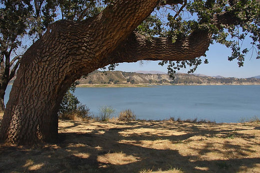
Dockweiler County Beach
Los Angeles, CA
50 miles: 5N to 405N to 105W
Today we rolled up our tepee, cranked over the horsepower in our covered wagon and took off on our annual "venture". We left San Mateo full of excitement for another six months on the road.
We left just in time, too, as the day after we left, a fire started at the north end of Camp Pendleton/south end of San Clemente. Dubbed the "Cristianitos Fire, because of its location, the fire lasted a few days, burning about 700 acres fought by about 200 firefighters.
Our first stop was at Dockweiler County Park, a lovely facility on the beach right at the end of LAX and next to the sewage treatment plant. Despite the offenses to senses of smell and hearing, this place was packed!


Stop #2: June 29, 2017
Flying Flags RV Park
Buellton, CA
111 miles: 105E to 101N to 246
As usual, when we take off, we have problems with the motorhome. Right before we left, our nightshade broke in the down position. We used bungee cords to fasten it in the up position until we can order a new motor and find a place to get it fixed. (It is now a month later, and we still haven't had it fixed.)
Our second and third issues were water pressure and then a water leak, which had to be fixed immediately. The bad news is that I had to listen to Roger spewing 4 letter word expletives until he arranged for a viable solution to this crisis. The good news is that we found a mobile RV service provide right across the street from Flying Flags. Even better news is that they were able to squeeze us into their already hectic schedule at a very busy time of the year over the busiest weekend of the year. The best news is that the leak got fixed and didn't cost us an arm and leg.
Stop #3: July 1-6, 2017
Pacific Dunes Ranch RV Park
Oceano, CA
41 miles: 246 to 101n to 1N
We stayed at our favorite haunt, Pacific Dunes. Located in Oceano, just north of Pismo, this relatively isolated RV park is just off the dunes, on a slight hill.
One night we went to the Great American Melodrama Theater and saw "The Karaoke Kid", a parody on that awful movie with a similar, unnamed name.


We stopped by the Monarch Butterfly Grove, not busy at this time of the year. The Monarchs from West of the Rockies summer in Western Canada and winter in Pismo. Monarchs from East of the Rockies summer in Eastern Canada and winter in Mexico. (We learned this Fun Fact this summer from Crissie, Park Aid at San Mateo, in her Summer Series talk about Monarchs.)
We saw that several of the eucalyptus trees that the Monarchs occupy were down probably as a result of our heavy wet winter. We hope there are still enough trees for them to return to this location this coming winter.


We always enjoy the experience of driving on Pismo Beach. It is always so quiet and relaxing.
What we can't understand is who would want to bring their motorhome down here to get buried in the sand and have sand everywhere inside the living space? Or what if there was a high tide and the motorhome just floated away? (A park aid at the Kiosk at Pismo said that has happened.)


(Why are people are flying Mexican flags on our American Independence Day?)

There are fireworks stores all over town. (You remember them....temporary buildings set up in parking lots with big bold signs all over them: "Fireworks".) But in Pismo, for every store, there was a nearby sign" "No Fireworks Allowed Here", including on the the beach. So where are you supposed to set them off if you buy them?
We didn't have any kids with us, so we weren't going to buy our own anyway. We wanted to see some community fireworks, if we could, so we asked one of the camphosts, "Excuse me, sir, where's the best place here at Pacific Dunes, to watch the fireworks tonight?"
"Oh, on the pier," he nicely replied.
Not wanting to venture out by car to go anywhere, especially anywhere close to Pismo Beach and the pier, we replied, "Yes, we understand. But what about HERE? In the Park?"
"Down at the beach."
"Yes, but what if we don't want to leave the Park?" we patiently queried.
"From the top of your motorhome."
We wanted to yell at him, "Are you crazy? Have you looked at us? We are senior citizens. Would you seriously recommend that we voluntarily climb on top of our motorhome? In the dark? Does the park want a lawsuit?"
But we didn't yell at him. We smiled, thanked him, and went on our way.
We did not leave the campground that night.
We did not climb on top of our motorhome.
We did, however, climb to the top of the small hill in the campground and joined a few others in watching fireworks in the distance at the 5 surrounding cities including Oceano, Pismo, and two others. That's why the fireworks in our picture are so small.


One day we drove to Piedra Blancas, near San Simeon, to see the North American Elephant Seal rookery. This rookery has a population of about 20,000 seals out of a worldwide population of about 170,000. At one time, there were hundreds of thousands of these behemoths in the Northern hemisphere, but were hunted for their blubber and neared extinction by the 1820s. With only a population of 50 to 100, they have since made a tremendous comeback, with the population growing exponentially since the 1970s.
At one time, this location only had seals during their bearing months, Dec-Mar. Now there are seals year round, at various stages of their lives. Summer is for molting, first females, then males. Fall is for mating, and Winter/Spring for raising young. We were there during male molting and there were only a few hundred in this area.


One day we drove to the Avila Beach area. We had lunch at Port San Luis. There were sea lions in the harbor, fishermen on the pier, RVs on the hill and tourists everywhere else.


Another day we drove to Lake Cachuma and stopped for lunch at a delightful outdoor restaurant in one of the towns near the lake. It was nice to see water again in the lake, after so many years of drought.
On our last full day we drove to Shell Beach just north of Pismo. It is such a beautiful spot. Words are not needed to describe the beauty and serenity of this place.


Is that pelican yawning?


Stop #4: July 6-8, 2017
KOA Salinas/Monterey
Salinas, CA
153 miles: 101N
Cannery Row became famous because of one its residents, John Steinbeck. A man of the ordinary and downtrodden, he wrote about the lower echelon of our society, highlighting their differences and altercations with those with money and power. Wouldn't he be appalled to see Monterey today? Only the wealthiest of California can afford to even eat there, let alone live or play golf.
We took the famous 17 mile drive through Pebble Beach. This scenic drive was created in 1881 by Charles Crocker and was traversed by visitors in horsedrawn carriages. Samuel Morse, founder of Pebble Beach Links which opened in 1919, described this area as "the greatest meeting of land and sea in the world." That explains why the drive is crawling with tourists for more than a century.


Both of us I played tourist, too. Look at Roger taking a picture of Ellen taking a picture of Roger. And look at Ellen with all those cameras!


They're hard to see because they are so far away, but those are sea otters floating on their backs amongst the seaweed, in a calm bay about 100 yards off the coast.
Here is the Lone Cypress, one of the most photographed trees in the world. Its iconic image is the logo for Pebble Beach Resorts. This corporation must be the driving force to help keep this 250 year old tree alive until at least 300 years. (When it dies, they will have to change their logo, and think how much that will cost!)


We watched a bothersome group of young, non-English speaking visiting Japanese, tittering loudly among themselves while snapping selfies and groupies with their sophisticated Japanese cameras, using the Lone Cypress as a backdrop.
Thankfully, the Japanese like to travel together in large groups, so their tour buses dutifully dropped them off at the tree, and after 15 minutes of laughing and snapping, the buses picked them all up and they were whisked away to their next photo-op spot.
(Sincere apologies to our Japanese friends. No offense intended.)
Stop #5: July 8-13, 2017
Thousand Trails South Lake Tahoe
South Lake Tahoe, CA
265 miles: 101N to 152E to 5N to 50E
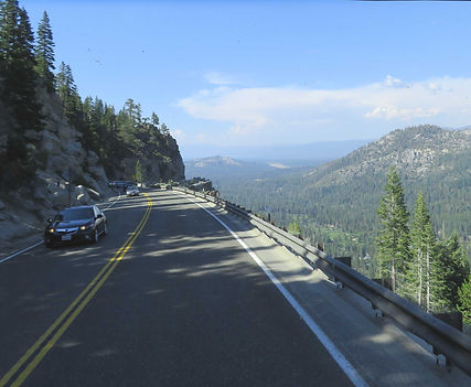
We drove up Highway 50 over Echo Summit at about 7800 feet to get to South Lake Tahoe. Every time we take this drive, either over Echo or Donner Summits, we think of the pioneers crossing these rugged mountains by foot, horseback, or in wagons. It is so different than our luxury cars (and motorhomes) on super highways. Our ancestors were really tough people to be able to do this.
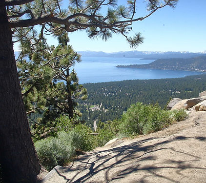
Lake Tahoe
Mark Twain called Lake Tahoe "the fairest picture the Earth affords." We couldn't agree more. Especially in the summer, when the weather is perfect and the colors are vibrant, we truly appreciated this jewel in the middle of the Sierra Nevadas.

Fun Facts About Lake Tahoe:
-
Largest alpine lake in North America (an alpine lake is higher than 5000 feet)
-
1645 feet deep, 22 miles long, 12 miles wide
-
Second largest lake in US, (first is Crater Lake)
-
Shoreline is 75 miles long
-
Water is so clear, objects can be seen down to 70 feet in some locations
The South Lake Tahoe Thousand Trails is nice because there are a lot of trees. The downside of a lot of trees was no satellite reception. Sigh.


A trip to Tahoe is not complete without a drive around the Lake. The most spectacular sight is Emerald Island.
We had a lot of snow this past winter, more than we've had in many years. There was evidence of it everywhere. There was still snow on the highest peaks. There were many waterfalls.


Alpine meadows were lush.
Do you see that pole next to the jeep? That's a snow level marker. This gives you an indication of how high the snow was on the East side of the Sierra this past winter.

Even though there was still snow, skiing had already finished for the year.

On the Nevada side of the Lake, we looked East and saw how full Washoe Lake was, outside of Reno.


Here's a tunnel in Nevada on the north side of the Lake.
Here are two views of Lake Tahoe from the East side:
-
The picture to the right looks North.
-
The picture below looks to the South.

Stop #6: July 13-15, 2017
Happy Campers RV
Dunnigan, CA
200 miles: 50W to 5N
Colusa
We hated leaving the mountains. But our "venture" continues, so we reluctantly drove down the hill and then up the 5.
We stopped in Dunnigan for a couple of days so we could visit Ellen's family in Colusa and Williams.
Here is Ellen's Dad. He is 99 and is now in a nursing home in Williams. This picture was taken on a good day in May. He knows he has daughters, but doesn't remember our names most of the time.
Below are Ellen's sisters:
-
Older sister, Betty, on the left
-
Younger sister, Caroline, on the right


Stop #7: July 15-17, 2017
Shoreline RV Park
Eureka, CA
180 miles: 5N to 299W to 101N
North Coast
There is no easy drive from the Sacramento Valley to Eureka. We took the best one, Highway 299. Even that is constantly under construction.
In some places, the road is narrow, especially for our motorhome.

Highway 299 is one lane in each direction and goes through many small towns, such as Weaverville (the town where Ellen's father was born almost 100 years ago).

There was one particularly rough patch which really jostled things in our motorhome. It appeared that this section might have washed out during last winter's storms.

Our RV Park was one of the cleanest we've been in for a long time. It was all asphalt and grass. Having come from the beach (sand) and the mountains (fine dirt, like powder which gets in everything), this was a nice change.
However, the RV park was right off of 101, adjacent to a gas station on one side and a Harley Davidson dealership on the other. So it wasn't particularly quiet.
In addition, parked in site #1 was a Health and Human Services mobile health unit. Perhaps it was for the homeless, the population of which is very high in Eureka.


Old Eureka,on the harbor, has lots of old homes many of which are more than 100 years old.
William Carson, a pioneer lumber baron, built a home there in the late 19th century. It is now a private club.
He also built another home across the street, the "Pink Lady", completed in 1889, as a wedding present for his son, Milton. It was pink so as to contrast the darkness of the father's home.There are two Carson mansions there, too.

One day, we drove on the Redwood Highway. Fun Facts about Redwoods:
Coast Redwoods Giant Sequoia
Location: Pacific Coast, CA, OR West. Sierras
Height: 380 ft 311 ft
Age: 2000 yrs 3200 yrs
Bark: 2 in. thick 31 in. thick
Base: 22 ft diam. 40 t. diam
Reproduce: Seed or sprout Seed
Cone size: Olive Chick. egg
We went to Patrick's Point State Park, north of Eureka. This park is a spectacular gem in the CA State Park system.


The California bear was in a museum. Everything else is outdoors in natural environments.


Patrick's Point is just north of the town of Trinidad, discovered by the Spaniards in the late 1700s. It has a small, rocky harbor and pier for fishermen.


We also stopped in Elk Meadow, to see the Roosevelt Elk, largest in North America. They weren't up for posing for pictures the day we were there.

